Faculty Lane ran along the north side of the core campus of Concordia College in Seward. The core campus occupied a square area that measured about 200 yards on each side. The front of the campus is Weller Hall, which faces Columbia Avenue.
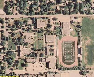
There is a good map of the campus at this webpage, but I have not been able to embed it into this blog. In the meantime, we will make do with this aerial photograph:

Columbia Avenue is the street running vertically along the left edge of the image. The large building to the right of that street is Weller Hall, and it is the front of the campus. The sides of the campus are described as follows:
* Behind the campus, on the east side, lay a football field. (About two football fields could have fit along that side.) At the north-east corner stood an athletic building that had been built only a couple years before our arrival, perhaps in about 1958.
* Along the north side of the campus stretched Faculty Lane, a row of eight large houses. In the image, the prominent street running horizontally along the top of the image is East Hillcrest Drive. Faculty Lane is a crooked street a little lower, on the left side of the image. In the image, that crooked street runs into a large building, which is the college's Music Building. The area of that Music Building previously was occupied by four houses, which were removed in 1964.
* Along the west side stretched Columbia Avenue. At the intersection of Faculty Lane and Columbia Avenue, on the Columbia Avenue side of the street, stood St. John Elementary School. If you walked south from this school along Columbia Avenue there was a row of large houses, similar to the row of houses on Faculty Lane.
* Along the south side stretched College Avenue. Across that avenue stood a row of dormitories. I imagine that those dormitories had replaced a row of houses similar to those that still (in my time) stood along Faculty Lane and Columbia Avenue.
In 1960, Concordia College was at the northeast edge of Seward. Beyond the football field lay only farm fields. Beyond the athletic field there were three or four short streets with homes, but further was open country.

In this aerial photograph, the prominent street running horizontally all the way across and just a little below the image's center is Hillcrest Drive. (You can see the football field a little below Hillcrest Drive on the image's right side.) The image shows a large residential area in the top, right part of the image, above Hillcrest Drive. In 1960, most of that area was open countryside.
If you stood at the west end of Faculty Lane, across the street from St. John’s Elementary School and then walked north, you walked into a rural area after only one block. When we arrived in 1960, the Schlueter family lived there, a block away from the school, and they raised ponies on their property. They had a large barn and a corral for the ponies.

No comments:
Post a Comment